SNOWSHOEING TRAIL - COL DE ROCHELOTTE

  • Raquette
Array
Distance in kms : 2,5
Difference in altitude : 100
Blue

Map

- Departure/Arrival
- Point of interest
Circuit n° 1
Circuit n° 2
Circuit n° 3

Presentation

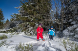
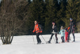
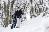
Marked  Snowshoeing trail starting from  the car park above the Holiday Centre Azureva : Track 2 Col de Rochelotte.

Length of the trail: 2.5 km - elevation: + 100 m - Duration : 1h30.

Route in a return, you will walk in the forest until you reach the Rochelotte shelter.

The GPx track is available for download above.

The map of the snowshoeing routes of the Hautes Vosges mountains is downloadable here above.

Good to know
  • Documents available in: :
    • English
    • German
    • Dutch

Pics

  • randonnee-raquettes-rochelotte-bussang
  • randonnee-raquettes-rochelotte-bussang-1
  • randonnee-raquettes-rochelotte-bussang-2
  • randonnee-raquettes-rochelotte-bussang-3
randonnee-raquettes-rochelotte-bussangrandonnee-raquettes-rochelotte-bussang-1randonnee-raquettes-rochelotte-bussang-2randonnee-raquettes-rochelotte-bussang-3
Contact details of the owner
SNOWSHOEING TRAIL - COL DE ROCHELOTTE
Larcenaire
88540
BUSSANG
mail / message
FICHE_INFO_SIMPLE_ECRIRE_MESSAGE
Fields with an asterisk * must not be left blank
My request
Your Contact Details
In accordance with Law No. 78-17 of 6 January 1978 of the National Committee for Information Technology and Civil Liberties (CNIL) with regard to computing, files and liberties (article 36), the interested party is entitled to ask for his/her personal information to be rectified, completed, clarified, updated or deleted if it is inaccurate, incomplete, ambiguous, elapsed or in respect of which it is forbidden to use, disseminate or store said information. Should you wish to exercise this right, please specify the fact in the form above.
We also suggest...