Mtb itinerary n ° 2 - Mont de Fourche - departure: Col du Mont de Fourche
- Mountain Bike
Distance in kms
:
5
Difference in altitude
:
110
 Departure/Arrival
 Point of interest
Circuit n° 1
Circuit n° 2
Circuit n° 3
Presentation
Signposted circuit starting from the Col du Mont de Fourche.
Circuit n ° 2 "Mont de Fourche".
Difficulty level: green.
Distance: 5 km.
Elevation: 110 meters.
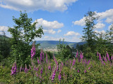
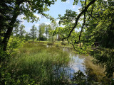
Circuit which allows you to discover the Chalet des Sapins, a peaceful pond and pretty views over the village of Rupt-sur-Moselle from the heights.
The map of the Hautes-Vosges mountain bike circuits can be downloaded.
The GPX track of the route can be downloaded below.
Opening day(s)
All year long -2024
Every day
Good to know
- Documents available in: :
- English
- German
Photos


Contact details of the owner
Mtb itinerary n ° 2 - Mont de Fourche - departure: Col du Mont de Fourche
route du Mont de Fourche
Col du Mont de Fourche
88360
RUPT SUR MOSELLE
Phone : +33 3 56 11 00 90
We also suggest...


