Trail route n°1 - La Chapelle des Vés
- Trail
 Departure/Arrival
 Point of interest
Presentation
Length of the route: 9.44 km – Elevation gain: 470 m – Duration: 1 hour 10 minutes to 2 hours 20 minutes – Markings: Trail sign n° 1 green + Club Vosgien sign – Level: easy.
Start: Church car park.
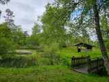
This route begins with a magnificent first climb through the woods above Le Thillot. After a few beautiful switchbacks in the forest, the pond and hut at Chaillon offer a welcome break before continuing on to the highlight of the day: the Pic des Corbeaux with its magnificent panorama.
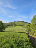
The climb continues to Draimont, which leads to the Chapelle des Vés, before a gentle descent allows you to lengthen your stride.
One last effort below the summit, then it's back to Le Thillot to finish this short but challenging outing.
The routes on your smartphone...
All the routes of the Espace Trail des Ballons des Vosges are available free of charge on your smartphone thanks to the Trail Connect app in the ‘Destinations à découvrir’ (Destinations to discover) section.
GPX and PDF files of the tour can be downloaded below.
All year long 2026
Every day