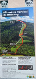
VERTICAL KILOMETRE TRAIL

Array
Distance in kms : 7,5
Difference in altitude : 1000

Map

- Departure/Arrival
- Point of interest

Presentation

What is a vertical kilometre trail ?

1 x 600 m + 1 x 400 m ascents to reach 1000 m elevation, thus the vertical kilometre.

Please note that you are on a protected natural area, please respect the periods of practice: July, August and September.

How  doing the ascent of this kilometre ?

Start: Bussang Tourist Office

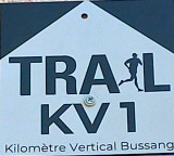
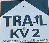
Follow the KV1 marks (600m elevation), then descend to reach the start of the remaining 400m and follow the KV2 marks to go up along the former Bouloie ski slope to the Tête de la Bouloie over a length of more than 7 km to reach the vertical kilometre.

A guide is available to accompany you if you wish: BILOBAREV - Matthieu FRANÇOIS : + 33 (0)6 87 74 22 69 / bilobarev@orange.fr / www.bilobarev.fr

Opening day(s)

From Monday 01 July to Monday 30 September 2024

Every day

Pics

  • parcours-trail-km-vertical
  • parcours-trail-km-vertical-2
  • parcours-trail-km-vertical-3
parcours-trail-km-verticalparcours-trail-km-vertical-2parcours-trail-km-vertical-3
Contact details of the owner
VERTICAL KILOMETRE TRAIL
8 avenue de la gare
88540
BUSSANG
mail / message
Phone : +33 6 87 74 22 69
FICHE_INFO_SIMPLE_ECRIRE_MESSAGE
Fields with an asterisk * must not be left blank
My request
Your Contact Details
In accordance with Law No. 78-17 of 6 January 1978 of the National Committee for Information Technology and Civil Liberties (CNIL) with regard to computing, files and liberties (article 36), the interested party is entitled to ask for his/her personal information to be rectified, completed, clarified, updated or deleted if it is inaccurate, incomplete, ambiguous, elapsed or in respect of which it is forbidden to use, disseminate or store said information. Should you wish to exercise this right, please specify the fact in the form above.