Hicking route l'ermitage de Frère Joseph

 Departure/Arrival
 Point of interest
Presentation
From the car park, go uphill on the tarred road. At the forest entry, turn on the left and take the large way marked with the green rectangle. After 250m, turn on your right, and go uphill on the path (green rectangle). Go straight on, for 750m, you will cross three large ways .
At the 4th way, turn right and go on this way, by following the same marks (green rectangle).
After 800m you can take the path on your right (marked blue ring “Croix de l’Ermite”) to have a look to the Cross of the Hermit, this little detour makes your hike 1km longer and arrives 200m after the Shleter Chalet de Forgoutte.
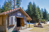
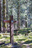
Otherwise, follow the way thraight on for 200m after this crossing, pass in front of the shelter chalet de Forgoutte (you can have a break there). 200m further, pass beside a wooden cross, on your right, called the Cross “Croix de Frère Joseph”. About 100m further, leave the green rectangle marks and follow the blue ring mark with the board “Frère Joseph direct”. Go thraight on, downwhill for 1km until you reach the Inn Auberge de frère Joseph (you can have a meal). If you want you can visit the chapel located at the border of the forest, in front of you.
To return, the way is at the corner of the Inn and leads on the edge of the forest. Take the way marked with the blue point and the board “Col du Collet”. 400m further you pass by a belveder with a very nice view on the village Ventron (blue point). After about 600m , leave this way and turn on the right uphill on the steep path with the board “Col du Collet 700m”, marked with the blue point. (Do not go on the path with the blue ring and the board “Croix de l’Ermite”).
At the Col du Collet, go on the way that leads downhill and marked with the blue diagonal cross and the board “Col de Rochelotte”. At the end of the path with a steep descent , turn on the right, on the large way makred with the red point and the board “Col de Rochelotte”.
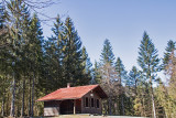
After 1.800km you arrive at the cottage Chalet de Rochelotte, follow the way on your left with the board “Bussang par Larcenaire” on 1.200km. This large forest road (marked green/white/green rectangle) leads you back to the car park.
All year long -2025
Every day
- Documents available in: :
- English
- German